

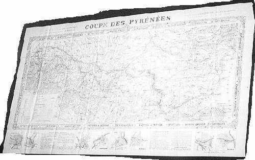
DE DION BOUTON Cup of Pyrenees
This period is characterized by the total cover of the territory, the generalization of the colors, the intervention of publicity and the arrival of new brands.
DE DION BOUTON
About 1900 DE DE DION BOUTON uses this support for its promotion, with an unquestionable talent. The decoration which uses the art nouveau very is successful and the back of the cards is covered with information and drawings bound for the customers: models of the range, engines, information on mechanics, addresses of the concessions of the brand... These Maps are among best moment by the quality of the impression, the detail and the colors.
In fact DE DION BOUTON is opening the way of publicity through this support, that will make it possible thereafter to strongly lower the selling price of the Maps.
DE DION BOUTON Cup of Pyrenees
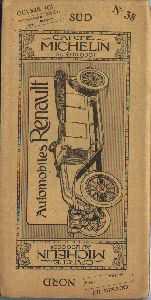
TARIDE
The prevalence at this period returns to the company TARIDE which with a very complete range and of good quality ensures the strongest sales.


Some Taride Maps were advertising.

Blondel la Rougerie
In the first years of the century, brand Blondel la Rougerie makes also his appearance. It is creative Maps guides CAMPBELL. It diffuses guides and Maps which are located at low prices, quality feels some on the models more running.

T.C.F.
The T.C.F. is very present, it realizes in addition to the current productions, of the more detailed Maps for the tourist zones, like the Massif des Maures on the scale 1:20000 about 1907 whose precision is rebrandable, one distinguishes the least building.


Its production covers all France.

It produces also Maps in partnership with editors geographes.

MICHELIN
This period sees also the beginning of the Michelin cards in 1910. Since 1900 the brand published the red guide which comprises at the end a small Map of France. Michelin diffused free this guide with its best customers. Andre Michelin after studies at the central school of PARIS with worked with the Ministry for the interior, with the service of the card to the 100.000ème, it is this knowledge to make which enabled him to set up the cartography like new axis of development for its company.
It is about 1908 that the first studies, for the realization of a series of Maps on France, started. And in 1910 that the first cards are diffused while starting with Clermont-Ferrand and then with cards at the edge of the Mediterranean and Paris area. The total cover of France, including/understanding 47 sheets, is entirely finished in 1913. The Maps are drawn entirely by Michelin, more than 3 000 copies are established (for each French canton).

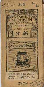
One of the significant contributions of Michelin is the crusade for the demarcation of the roads in 1911. Who allowed the motorists to better locate himself, fatty with the milestones numbered along the roads and the corresponding numbers indicated on the Maps.
Another improvement comes from folding and the replacement of the small pockets by a cover interdependent of the Map.
It is the beginning of a series of Maps which with finally, by its dynamism and its quality, allured the conductors and which always lasts.
The Editors Geographers.
The editors geographers of the previous century are always present, thanks to their collaboration with the large brands of roadmaps for which they create models. But they have also sometimes their own production, the majority were a retailer of the Maps of the geographical service of the armies. Among most known one can quote:
Forest (Paris) which worked much with the Touring-club of France.
Barrere Andriveau Goujon (Paris) which worked much with DE DION BOUTON and T C F.

The brand HACHETTE diffuses departmental cards about 1910; the little of precision and the lack of details, do not make it possible to really regard them as roadmaps. They were rather intended for an administrative use or of teaching.

Reviews and newspapers publish also sometimes Maps.

As well as automobile brands.
